Into the High Sierras: Walker Pass to Kearsarge Pass
6/5/2012, Kearsarge
Trailhead, 14.0 miles traveled.
I rose early to a crystal clear, freezing dawn. I enjoyed views of cascading Bubbs Creek and
mist rising off the surrounding Kearsarge Pinnacles. I joined up with my companions from the day
before, and we hiked off the PCT over Kearsarge Pass
in order to resupply. We all found rides
into Independence,
and enjoyed eating at a diner while we waited for the bus to Bishop. After a short bus ride, we arrived in
Bishop. The other hikers headed for a
motel, while I waited for Sarah to come and get me. We plan to return to the PCT together on June
9 now that school is out. I am anxious
to return to the beautiful Sierras.

Bubbs Creek.

Bubbs Creek.

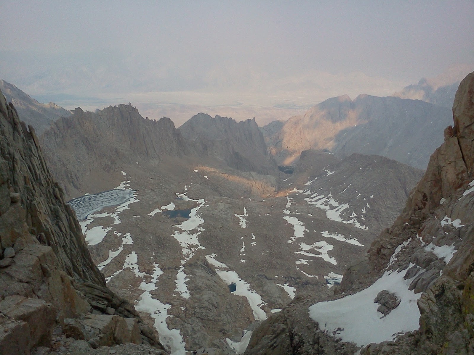
Looking south, back up trail towards Forester
Pass from Kearsarge Pass
trail.
6/4/2012, Near
Vidette Meadow, mile 785.0, 22.0 miles traveled.
I began hiking at 5:30 am after sleeping fairly well. I regained the PCT and headed towards Forester Pass, the highest pass on that
trail. During the long approach, the
wind kicked up from the south, and clouds began racing across the sky. I could hear a low humming sound, and
realized it was the wind blasting through the notches on the ridge that I would
have to cross. I was relieved to catch
Chief, Cookie, Memphis,
and Train at the base of the steep part.
We had fun crossing over the dramatic Forester Pass. There was less snow on the pass than when
Sarah and I had crossed it during late July three years previously. We descended below tree line just as it
started to rain. I figured my tube tent
wouldn’t stand up to the wind, so I sought shelter under a large boulder. It was so cramped that I couldn’t roll on my
side. I spent a long night watching
clouds race across the face of the moon.

Deer near Timberline
Lake.

Approaching Forester
Pass (notch in center
under cloud).

Steep section on south face of Forester Pass.

View northwards from Forester Pass.

JayBird on Forester
Pass.

Looking back at the north face of Forester Pass.

Chief, Cookie, and Train traversing snow on descent from Forester Pass.

Storm blowing in towards Kearsarge area.

Seeking sheltered campsite during storm.
6/3/2012, Above
Guitar Lake, 18.0 miles traveled.
I awoke to the sound of a drumming grouse at 8:00 am. I felt refreshed and ready to hike. I made Crabtree Meadows around noon, and
began a 16-mile side trip (round trip) off of the Pacific Crest Trail to climb Mount Whitney, the highest peak in the lower 48 states at
just less than 14,500’ elevation. I
enjoyed meeting several familiar thru-hikers as they were returning from the
mountain. I reached the summit at about
6:00 pm. I only had to cross one patch
of snow. The air was hazy due to a
forest fire to the south. Darkness
caught me by the time I descended to 12,000 feet elevation, so I camped on a
bench above Guitar
Lake. I enjoyed watching the moonlight on the steep
mountainsides as I drifted off to sleep.

Sequoias and typical clean understory in Kings Canyon
National Park.

Peering through Sequoia snag.

View northwards on approach to Crabtree Meadow.

Crabtree Meadow.

Mt. Whitney from Timberline Lake.

Feisty marmot.
Smokey view east from Mt. Whitney.

Registration box on Mt. Whitney
summit.

View south along summit ridge of Mt. Whitney.

View northwards from Mt. Whitney.

Warning sign I didn’t notice until I was on the way down.

Descending Mt.
Whitney.
6/2/2012, Past Rock
Creek, mile 761.0, 20.0 miles traveled.
Once again, I slept poorly.
A sub-freezing breeze blew down along the creek for most of the
night. I crawled in between the plastic
layers of my tube tent for awhile. Then
I became concerned that the bag would loose all its insulating capacity as my
body vapor soaked it, so I crawled back out on top of the plastic. Soon, the outer surface of my bag was
frozen. That seemed to reduce the heat
loss to the wind, and I was able to catch a few hours of sleep before dawn. I tried to catch a little more sleep after
the sunlight reached the creek. I began
hiking at 9:00 am, and ascended past Horseshoe Meadows to Poison Creek. By then I felt horrible, with a headache,
nausea, and listlessness. I remembered
feeling similarly when Sarah and I had started our hike of the John Muir Trail
at this point three years previously. I
figure that I was feeling the effects of the high altitude. Tired of sleeping cold and hiking hot, I
decided to take advantage of the full moon.
I found a secluded spot in the shade of a granite outcrop, and slept all
day until 8:00 pm. Feeling listless, but
with less of a headache, I began hiking at 9:00 pm. I hiked all night under the full moon. I lost the trail briefly after Chicken Spring Lake,
but used my map to regain it. I crossed
high country near Cottonwood Pass, and then began the long descent towards Rock
Creek in Kings Canyon National Park. The forested north-facing slope was very
dark, so I used my headlamp for the last part of the night hike. I tried not to think of mountain lions. I scared myself once when my ice axe scraped
a boulder and it sounded like a lion scream.
I forded Rock Creek, and found a flat spot as I climbed out of the
canyon at 3:30 am.

Trail to Horseshoe Meadows.
Back on familiar trail. I had
hiked the PCT between Horseshoe Meadow and Tahoe City
in sections previously.
6/1/2012, Diaz Creek,
mile 741.0, 22.0 miles traveled.
I didn’t sleep very well.
I guess I wasn’t used to sleeping so near other hikers. They got up at 5:00 a.m., so I did also. It was a cold morning. I ascended to 10,500 feet and enjoyed views
northwards across Death
Canyon to the
Sierras. After descending into the
canyon, the trail climbed again to above 10,000 feet. It was a hot day. I was buzzed by a fighter jet as I crossed a
notch in the ridge line. It couldn’t
have been more than 200’ above me. It
was so startling, that I involuntarily dropped to the ground as the sound hit
me. I heard several grouse drumming as I
began a long descent towards Diaz Creek.
Clouds rolled in, and they spit rain off and on for the rest of the
afternoon. I was very tired by the time
I reached Diaz Creek. I fell asleep
gazing at a large ¾ full moon.

Looking northwards across Death Canyon.

Clouds rolling in from the southwest.
5/31/2012, Cow Creek,
mile 719.0, 16.0 miles traveled.
I enjoyed visiting with other hikers as I waited for the
general store to open at 9:00 am. I
charged my phone when I heard the generator turn on. I then mailed my discarded gear home, and
reached the trail at 9:30 am. After
traversing another burn, I emerged into beautiful Monache Meadows, and enjoyed
views of the South Fork of the Kern River and
the High Sierras. I set up camp in the
forest near Cow Creek, and was pleasantly surprised when I was later joined by several
more thru-hikers. We had a pleasant
visit and turned in at dark. We were all
excited to be near the Sierras.

Relaxed morning at Kennedy Meadows general store.

No Amp and Train.

More burn.

Monache Meadows.

South Fork of the Kern River.
5/30/2012, Kennedy
Meadows, mile 703.0, 19.5 miles traveled.
I awoke after a good night’s sleep and began hiking at 8:00
am. I soon noticed fresh bear tracks on
the trail headed back towards the spring.
It looked like I had just missed a sow and her cub, as the bear tracks
were on top of those left by a hiker who had passed by my camp earlier. I enjoyed a gradual ascent through a quiet
forest. When I reached the top, however,
I emerged into a huge burn, and began descending into the Kern River Basin. I was elated to see my first glimpse of the
high Sierras on the horizon. I reached
the South Fork of the Kern River. I was surprised to see how low the flow
was. It appeared that the spring runoff
was over. I made Kennedy Meadows just
before the general store closed, and picked up three packages. Kennedy Meadows is a community of 200
people. There is no electricity. Other than the store, the only facility is
Trail Angel Tom’s, where all of the thru-hikers congregate. I sorted gear, and enjoyed a taco dinner
supplied by the generous angel. I
enjoyed talking with Wrong Way,
who I had seen last year on the Appalachian Trail in the White
Mountains, and three years ago on the Tahoe Rim Trail. I swapped my new pack for my old, larger one,
and stuffed in 6 days worth of food. I
reluctantly strapped an ice axe and crampons on the outside of the pack,
figuring it was better to be safe than sorry on Forester Pass. Without water, my pack weighted 29
pounds. A young lady named No Amp
weighed her pack just before me, and hers weighed 50 pounds. I slept in the woods behind the store.

Track of hind foot of black bear cub near Fox Mill Spring.

Descending through large burn towards Kennedy Meadows.

South Fork of the Kern River.
5/29/2012, Fox Mill
Spring, mile 683.5, 17.0 miles traveled.
After a cold night, I began hiking at 8:00 am. I descended to Spanish Needle Creek, and then
climbed to another ridge top. As I
topped the ridge, I was delighted to hear my phone receive three texts. They were all from Sarah. Later, I realized that I was out of Part A of
the Aquamira I use to treat drinking water.
It was irksome to run out of one part, while I still had half a bottle’s
worth of the other. I would have to
drink untreated water until I reached my mail drop at Kennedy Meadows. I decided to utilize springs rather than
creeks if possible. I met several other
friendly thru-hikers throughout the day.
I decided the hike was more fun when I met several hikers a day rather
than being ahead of the pack. I found a
cache of sodas in Chimney Creek left there by a trail angel. I had a Sprite, while visiting with Tank and
On Time, and then ascended to Fox Mill Spring.
I set up camp, and spent the evening relaxing and gathering 5 liters of
water. The pipe dripped at a rate of 1
liter per 25 minutes, so it took a while.
I was relieved to feel better than I had the previous day.

Unusual, red thistle.

Dripping pipe at Fox Mill Spring.
5/28/2012, Past
Joshua Tree Spring, mile 666.5, 14.5 miles traveled.
After eight wonderful zero-days at home, Sarah dropped me
off at Walker Pass around 11:30 am. I then began a shaky ascent back into the
mountains on quivery legs with my payload of 5 liters of water and 4-days-worth
of food. I felt listless and had a headache. After the trail reached the Jenkins/Owens
Saddle at about 7,000 feet elevation, I had spectacular views eastwards across
the Hwy 395 corridor. It was very warm,
and lizards were out en force. One
lizard sported vertical orange stripes. I nearly stepped on a large non-venomous snake
(perhaps a king snake). I saw strange
looking yucca blossoms with swarms of pollinating flies around them. The trail then descended from pinion pines
back into Joshua trees. I began looking
for a campsite at 6:00 pm. I had decided
to put more effort into finding comfortable spots to avoid becoming run down
due to insufficient sleep. For this leg
of the hike (Walker
Pass to Kearsarge Pass
Trailhead), I decided to use a cheep plastic tube tent for shelter rather than
the tent fly. I intended to use the tube
tent primarily as a ground cloth. If the
weather was cold and windy, I would simply crawl between the plastic layers to
stay warm. If it rained, I would string
a line through it and fasten the ends to trees.
I found a flat spot on a ridge top at 6:25 pm. It was windy, at first, but it became calm
after sunset. I enjoyed talking with
Castle when she passed by near dark. She
had worked as a ridge runner for the Appalachian Trail Conservancy in Maryland the previous
year. As I lay on my back gazing at the
stars, a huge silhouette loomed a few feet above my face. At first I thought it was a bat, but as it silently
swooped and ascended, I realized it was an owl.
Then it came in for another pass, lower this time. I gave a whistle, and it veered off and
eventually perched in a tree behind me.
I had uneasy thoughts of it returning to clutch my face after I was
asleep.

Looking back while ascending into mountains north of Walker
Pass.

Lizard with orange stripes.

Yucca blossom and view eastward from near Owens, Jenkins
Saddle.
No comments:
Post a Comment